Hartest Walk
- BigAL

- Jan 11, 2015
- 2 min read
Updated: Aug 31, 2019
Hartest lies in the west of suffolk midway between Bury St Edmunds and Sudbury on the B1066. Hartest hill is said to be the steepest in Suffolk and the green is at the heart of the village with the Pub, School, Church,Butchers, Garage, Doctors and the Hartest Store on it.
Details of Walk

Date of Walk: 11/01/2015
Distance: 5.23 Miles
History:
Car Park: Village Hall (Free) IP29 4BH
Refreshments: The Crown
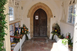
On this walk there was just the two of us and of course the dogs they never want to miss out on one of our walks. As it says in the description above Hartest village has a large green split up by small roads going through it and this is where we started the walk parking the car behind the village hall. From here we crossed the green on one of the roads on the south side passing the Crown Inn and All Saints Church. Leaving the green behind us we walked along the road and up the Harvest Hill which was steep.

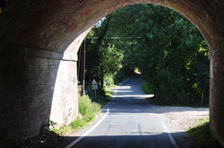
When we got to the brow of the hill the rest of the walk along the road was on level ground. When we got to the T junction where we turned right, on the corner was Gifford's Hall where they had black sheep grazing. We followed this road till it swung left at Dale's Farm and here we carried straight on down hill on a bridleway heading towards Boxted. When reaching a road we turned right and kept on this until we came to a turning on the left with a Boxted decorative village sign on the junction. Here we turned left went across the bridge with the River Glem running underneath and then up the hill towards Boxted Church which is called Holy Trinity. Round the back of the church you have good views looking over to Boxted Hall, We had a break here sitting in the porch before returning down hill to the village sign post and turning left along the road until we reached the road on the left signposted to Hawkedon. We followed the road to Hawkedon until we got to the first house and turned right at a footpath sign.

This path is known as Rodger's Lane and according to the directions we had it said it could become very muddy and overgrown, well I can tell you now it was walking up hill with water running down the middle and a tree that had fallen down to navigate round. When we got to the top of the hill we turned right on to a road heading down to Hartest. One more obstacle had to be encountered which was the road ahead had been flooded but a gentleman came out of a house just before it and said that we could come in and around his garden to avoid the water. The last bit of the walk was down hill with more wonderful views and ended up by the village car park.


Comments