Heybridge Basin Walk
- BigAL

- Mar 2, 2014
- 4 min read
Updated: May 28, 2019
Our first walk since 12th January as we have had so much rain this winter in fact I believe we have had the most rainfall at this time on record going back about a hundred years. So we needed to get back out there and decided to pick one from the Essex all year round walks which Trisha and Dave bought us when they were over last year. We picked Heybridge Basin as it was under the winter walk selection and it sounded as if there was hard paths most of the way.
Details of Walk
Date of Walk: 02/03/2014
Distance: 3.77 Miles
Level of Difficulty: A Easy Walk
Car Park: Daisy Meadow car park (Free) CM9 4RS
Refreshments: Pubs and Tearoom at the Basin
We had our walking companion Michael as he was over and he was all kitted out in his new walking boots he had bought after our last walk. These walks are good as it gets us to places we have never been to and this was one of them we have been to Maldon a lot of times and looked over to where we walking today but it was really good seeing Maldon and the promenade from the other side.
Heybridge Basin is located at the end of the Chelmer and Blackwater navigation and was originally a Neolithic settlement made up of 2 huts and a ditch, a few thousand years later there are a few more houses. Construction of the 13 mile canal to Chelmsford commenced in 1793 under the general direction of John Rennie.The basin at Heybridge was dug out at the sea end of the navigation to allow lighters to enter the canal via the sea lock for the unloading of their cargoes for transportation inland by the Colliers barges. The stretch of canal between the Basin and Beeleigh was cut out by hand to bypass Maldon because the town opposed the building of the canal fearing loss of trade in the port. In 1796 the first ship entered the basin with a cargo of coal for Chelmsford.

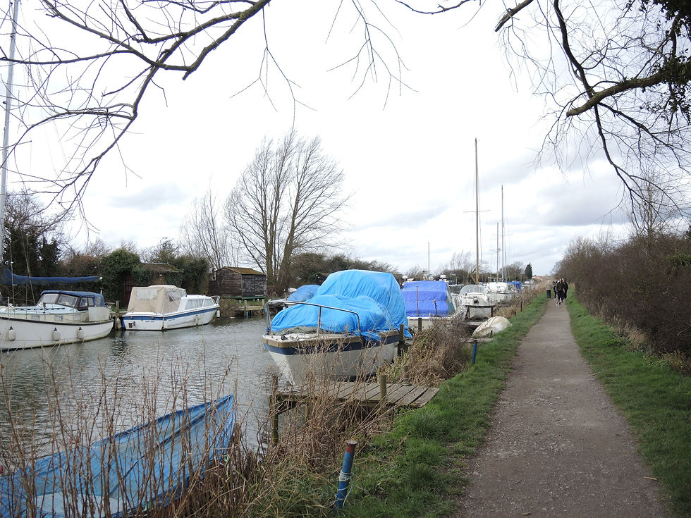
We arrived in Heybridge Basin and parked up in the free car park about 11:30am and set off across the car park to some steps that take you up on to the canal path. I nearly forgot to mention that last week was my birthday and was very fortunate getting a new camera to go with the Nikon D90 SLR which I have all ready got which is great but is a bit big and heavy and I wanted a lighter one to take out when we have family get together s and also on walks, the camera which probably will not mean a lot to anyone is a Nikon Coolpix P7800 so it was a bit experimental trying out different things the camera can do, the effects button is cool look what I done to the lock photo.

We followed the path alongside the canal heading inland towards Heybridge town as you are approaching there is a massive warehouse on the other side of the canal which was built in 1866 for the Bentall agricultural works. They made agriculture machinery like ploughs and later went on to build a car engine which had very low fuel consumption and was also one of the cheapest petrol engines on the market at the time. We crossed the canal over a ornamental bridge but I had suggested that we could have gone across this earlier on.
After walking through a industrial area which apart from seeing Heybridge from a different aspect and the only way to get to the next part of the walk it is not really what we want to see when we are on are walks. After leaving the industrial area behind us we headed back along the sea wall with the lakes on the left which used to be a gravel quarry and the mud flats and salt marshes of the Blackwater Estuary to the right.
As we progressed you get closer to the Hythe over on the other side of the estuary which used to be main quay of Maldon and it is still the main location of the famous Thames sailing barges with their characteristically furled chocolatey-red sails. A hundred years ago there were over 2,000 barges in the fleet. Many would carry hay and grain around the coast and up the Thames to London to feed the capitals horses and bring back manure on the return trip. These cargoes were known as the London Mixture. These barges with their flat bottoms were ideal for the Thames Estuary with its shallow waters and with a crew of only two these vessels were very efficient. They made a documentary called Thames Barge from a series Lost Routes of Britain.

Walking along the sea wall we were able to blow any cobwebs away as we were heading into the wind which was quite strong along the way. There is a lot of bird life to see of cause Seagulls, but there was Geese, Wading birds and there was attractive wrecks of old boats that had been left to rot.They transported a cargo of straw not from Maldon but from Great Wigborough to St Katharine’s Dock, for the program, broadcaster and comedian Griff Rhys Jones joined the crew on board the barge for the two-day trip. My Uncle John was one of the crew but mind you there was more than two this time and John was very excited about meeting Griff Rhys Jones and being in the documentary. There is only about twenty or so vessels left which are moored at the Hythe Quay and are available for charter.
Eventually we got back to Heybridge Basin and here you have the lock at the mouth of the canal which you have to cross over and then decide whether you fancy a beer and snack at The Old Ship or the Jolly Sailor or tea and cake from the tearoom called The Lock we went for the tearoom but we did not have tea we had coffee and Christine had a hot chocolate and yes we could not resist a slice of cake, so we shared a chocolate one and banana and caramel one. We will go back again in the summer on a Sunday afternoon if only to go back to the tearoom for another slice of the banana and caramel cake.


Comments